A couple of weeks ago we announced the launch of an exciting new project to research and reconstruct a porch on the front of Williamsburg’s iconic Raleigh Tavern. The project builds on previous documentary research that determined the presence of a porch on the Raleigh in the late 18th century. What the porch looked like, however, remains largely an open question.
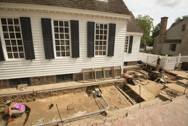
To that end, Colonial Williamsburg’s archaeologists and students enrolled in the joint Colonial Williamsburg/College of William & Mary archaeological field school, have spent the last month searching the ground between the tavern and Duke of Gloucester Street for clues to the porch’s location, size, and use. Knowing the answers to these details will help to ensure the eventual reconstruction will be as accurate as possible.
For example, a May 1773 Virginia Gazette advertisement documents an auction to be held “before the Raleigh Porch,” but gives no other detail. Likewise, local tradesman Humphrey Harwood’s 1779 account book includes an entry for “Repairing pillers to poarch” at the Raleigh, but said nothing of what those repairs consisted of, or the materials he used.
Perhaps the most revealing document is the 1782 Frenchman’s Map, which has long been an invaluable tool guiding Colonial Williamsburg’s archaeological efforts. Time and again the map has been one of our most reliable sources for building, fence, and even tree locations. But like the other documents, the map doesn’t include details such as when buildings or fences were constructed, or trees planted. Or what materials were used in construction: brick, wood, or a combination of the two?
Scale is another limitation. The map shows the relative size of buildings—small, medium, or large—but doesn’t give precise dimensions. In the case of the Raleigh Tavern, the Frenchman’s Map suggests the porch spanned most the tavern’s front elevation, but did not extend all the way to its corners. How far short did it stop? So while the Frenchman’s map provides a good start for thinking about what a porch on the Raleigh should look like, archaeological evidence could go a long way towards knowing the details.
As with any investigation, our ability to address these research questions is constrained by survival of archaeological evidence. In front of Raleigh Tavern, utility excavations, landscaping, and the 1930 reconstruction of the current Raleigh Tavern have all had impacts on the site’s 18th-century archaeological record.
No less than ten separate utility lines (water, sewer, power, and communications) have been unearthed thus far, each line carving through the soil that surrounds the tavern and displacing artifacts from their primary context. The tangled web of utility trenches has led more than one onlooker (and a few archaeologists) to wonder if there would be anything left to find.
Other visitors, noting that nearly everyone working on site was digging next, under, or over a pipe, have confused the archaeological field crew with plumbers and electricians. I think everyone will be much relieved to know that the field crew is limiting itself to the archaeology, and we are leaving the delicate work of keeping the water running and the power on to the trained experts.
But under that tangle of water, sewer, power, and communication utilities, we have been thrilled to see well-preserved traces of the development of the Raleigh’s 18th-century streetscape. Our first find was a patch of brick paving at the southeast corner of the tavern. In the coming weeks we hope to determine how that paving relates to the porch. Was it part of a sidewalk that pre-dates the porch’s addition? Alternatively, was it laid after the porch was torn off the tavern sometime around 1840? Or was it contemporary with the porch and was part of a sidewalk that led up to the porch?
Meanwhile, in the side walls of our many utility trenches, we’ve also recorded more than a foot of 18th-century soil build-up against the tavern’s south foundation wall that we have not yet had the opportunity to probe. In the coming weeks, excavation of those early layers may ultimately reveal the porch supports, be they wooden or brick piers, or perhaps a continuous masonry foundation.
Additionally, the excavation of those layers will hopefully result in the collection of artifacts that can help us to better understand how the Raleigh’s porch was being used. Perhaps, like many tavern porches, it served as an extension of its interior spaces, with room enough for seating patrons in fair weather. If so, we can anticipate recovering fragments of ceramic dinner plates and tavern mugs, wine bottles and glass tableware, as well as food refuse in the form of animal bones and oyster shell dumped over the porch railing—similar to deposits we previously excavated at other tavern sites such as Wetherburn’s Tavern, Shields Tavern, or even, Charlton’s Coffeehouse.
If you would like to support the Raleigh Tavern Porch Project and similar archaeological projects, you can do so by clicking here!
GUEST BLOGGER: MARK KOSTRO
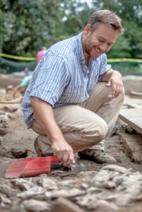
 Mark Kostro is a staff archaeologist with the Colonial Williamsburg Foundation and the director of the annual Colonial Williamsburg/College of William & Mary Field School in historical archaeology. Mark was born in NYC and raised in suburban New Jersey, but now calls Williamsburg home with his wife and son. He earned a B.A. in History and Anthropology from Rutgers University (1996), and a M.A. in Anthropology from the College of William & Mary (2003) where he is currently a doctoral candidate in Anthropology. He is a Registered Professional Archaeologist with more than 20 years of experience specializing in Chesapeake and Caribbean historical archaeology. Over the last decade he has overseen several large-scale archaeological investigations in Williamsburg including: Richard Charlton’s 1765 Coffeehouse (2008-2011), the Brafferton Indian School at the College of William and Mary (2011-12), and most recently, the Bray African American School (2012-14).

Susan Cottingham says
My family really enjoyed watching the Excavation today especially my daughter who usually tires of her archaeology Dad speak quickly!
This is fabulous! It is what CW is all about! Keep up the great scholarly work! You inspire more than you could know! Thank you!
Fraser says
Great work Mark!
Mark Kostro says
Thanks Fraser!
Did you remember to call Miss Utility first? 🙂
Mark Kostro says
We always do!
I love this! This is so interesting to me.
Here’s hoping the various renovations and utility excavations and installations haven’t so churned up the soil that you can’t determine the context of finds. Is there a difference between the brickwork of the 1700s and later construction which you help you with dating? Are you able to use dendrochronology?
Doing field work during the height of a southeastern Virginia summer - whew!
Mark Kostro says
Thanks Helene. As I wrote, we are very encouraged by what we are seeing in the ground and its level of preservation. We are able to sometimes determine a general date the masonry by the type of mortar used, as the so-called ‘ingredients’ for mortar changed over time. More often, however, we use artifacts buried in association with a brick wall or foundation to help us determine a more precise construction date. And as for dendrochronology, or tree ring dating, our colleagues in architectural research regularly use it to very good effect in the dating of standing structures. In archaeology, however, when working around buildings that are no longer standing, we rarely encounter a structure’s wooden elements, so we have to rely on other methods to determine a building’s dates of construction..
.
Mr. Kostro, please know that there is no ‘S’ on toward. Otherwise it’s a great article, and cannot wait to see what the team decides on size and construction. Thank you.,