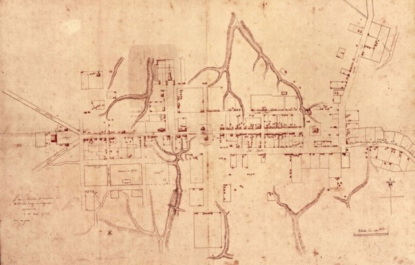
Whether one is looking for treasure or the closest Starbucks, most searches are more productive with a map. Colonial Williamsburg’s archaeologists are the first to admit this, which is why each of our excavations begins by consulting the Frenchman’s Map.
The Frenchman’s Map is a Revolutionary War-period map of Williamsburg. Hand-drawn lines record the town’s streets, buildings, fences, ravines- even rows of trees—as they appeared early in the 1780s. It is widely thought to be a billeting map, drawn to identify winter quarters for French troops following the Battle of Yorktown. Both its legend (“Plan de la ville et environs de Williamsburg en Virginie, America”) and labels (“Sud Street” and “Maison des foux”) reveal the French origins of its creator, though he never signed his name to the document.
The Frenchman’s Map was entered into official record in May of 1782, but what happened to it after that gets a bit murky. In 1909 it resurfaced in Norfolk, Virginia in a volume purchased by John D. Crimmins. Crimmins gave it to the College of William and Mary, which retains the document today. It was not until the restoration of Williamsburg began in the late 1920s, however, that the Frenchman’s Map would find prominence as one of project’s most valuable research tools.
For archaeologists, it’s a challenge to identify the single most important attribute of the Frenchman’s Map. Certainly the “snapshot” it provides of Williamsburg’s design and layout at the time of the Revolution nears the top of the list. Knowing which buildings, fences, and landscape features existed –and coexisted-in 1781 helps us know where to focus our excavations, and what to anticipate finding.
The Frenchman’s Map shows ravines (1); a row of trees bordering the Coffeehouse (2); and an unbroken line of buildings on the south side of Duke of Gloucester St. (3)
Beyond architecture, the Frenchman is a valuable guide through the 18th century landscape, identifying many features that are invisible to us today. Ravines, some of which have since been filled, are shown as “whiskered lines”; rows of trees –like those lining the approach to the Governor’s Palace — are depicted as dotted or dashed lines; and fences are solid lines. In 2009, archaeologists working east of the Coffeehouse were surprised to find a line of deep, clay-filled, tree holes bordering the edge of the property. Referencing the Frenchman’s Map, is seems clear that what we thought was an incompletely drawn fence was really the Frenchman’s notation for a tree-lined path.
So how trustworthy is the Frenchman’s Map? It depends. In places it is impressionistic, showing solid lines of buildings where we know that there were independent structures. Additionally, not every building is represented. Those structures judged unsuitable for housing soldiers (smokehouses, dairies, and stables among them) are rarely recorded. For example, the map shows no outbuildings behind Peyton Randolph’s large estate at the north end of town. Archaeological excavations, on the other hand, have revealed that during the Revolution the lot was heavily populated with outbuildings, including a massive two-story kitchen building and quarter for enslaved Africans. Is the map incomplete (as some have suggested), or was the household of the first President of the Continental Congress not expected to accept lodgers?
Those deficiencies aside, the Frenchman’s Map is perhaps our most universally trusted research document, and the first one that archaeologists reach for as an excavation begins. As we continue with this blog, you will hear frequent mention of the Frenchman’s Map. Want to know more? Check the following:
http://www.history.org/Foundation/journal/Autumn07/map.cfm
Meredith Poole, Staff Archaeologist


ntorch says
http://www.history.org/Foundation/journal/Autumn07/map.cfm
I would LOVE to see a super-high resolution scan of the map online. Is such a thing available and, if not, could it be so?